
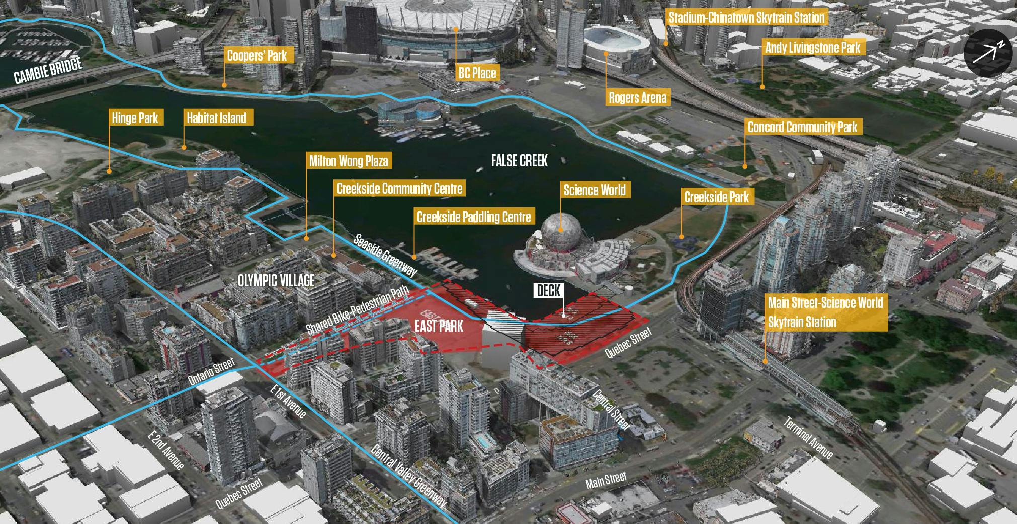
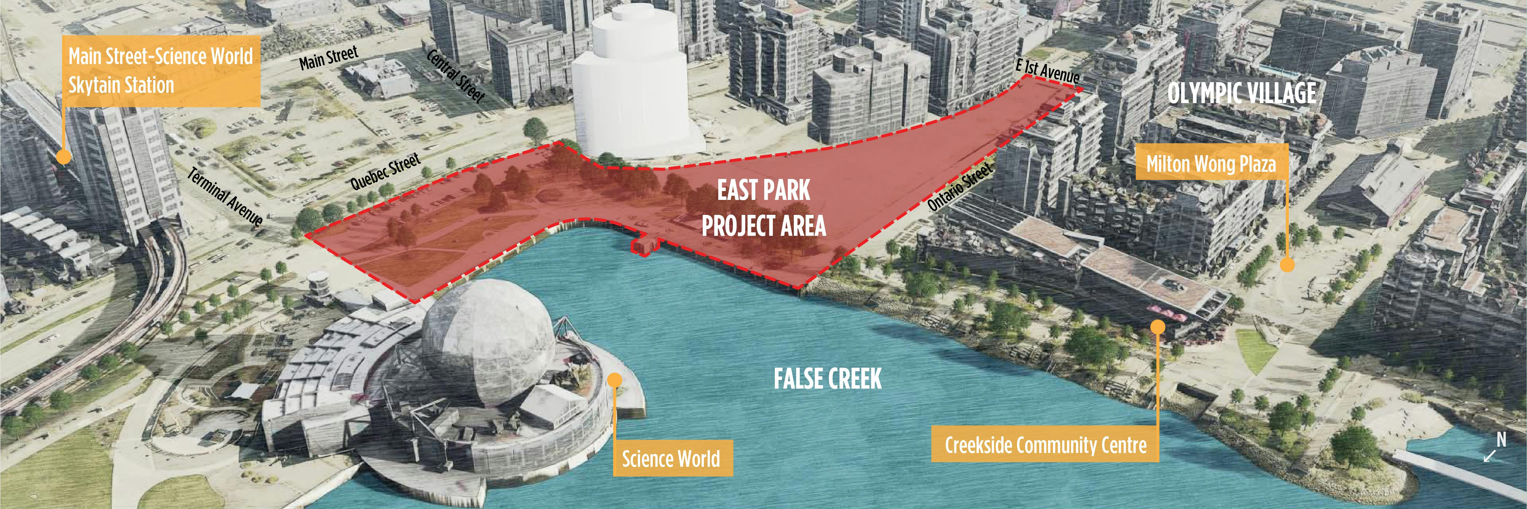
East Park
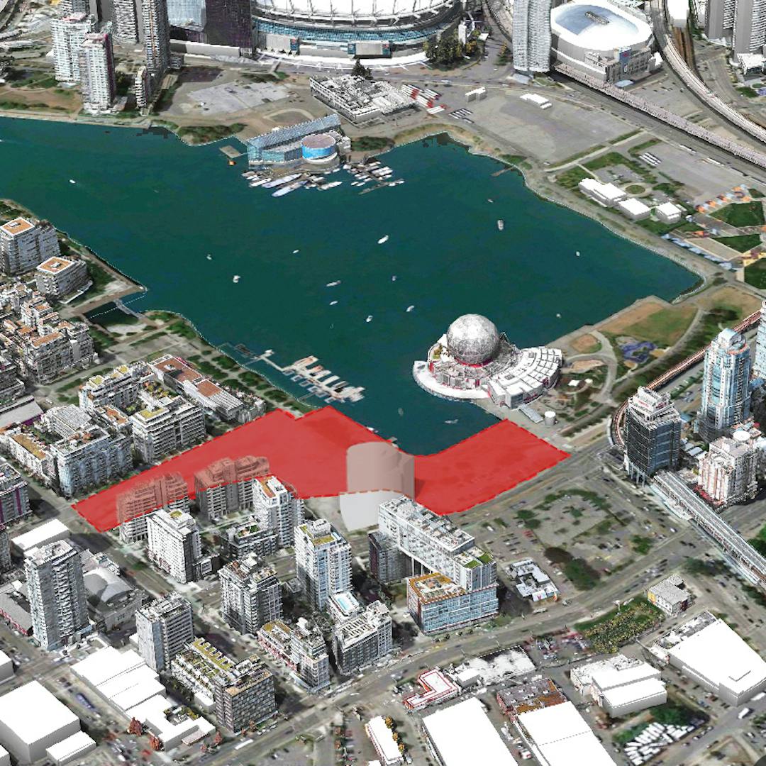
A new park is coming to False Creek, a unique place where city and water meet, on the ancestral and unceded territories of the xʷməθkʷəy̓əm (Musqueam Indian Band), Sḵwx̱wú7mesh Úxwumixw (Squamish Nation), and səlilwətaɬ (Tsleil-Waututh Nation).
The East Park* project is guided by the Guiding Principles for the design of parks in Northeast False Creek, and by what we heard from the local Nations and the public during the first round of engagement, held in the fall of 2022. This process identified five project goals as most important for East Park: nature, reconciling, circulation, belonging, and flexibility.
The project goals shaped the preliminary concept designs we shared with you in spring 2024 for the south side of the site between the Seaside Greenway and East First Avenue. The feedback received in this second round of engagement highlighted strong community support for a number of park design features including accessible connections to nature, biodiverse habitat areas, and flexible spaces to support a range of activities.** What we heard from the local First Nations and the public through two rounds of engagement shaped the proposed concept plan for Phase 1.
*The project area is currently called East Park, however we intend to identify an official park name through a separate process.
** Additionally, City of Vancouver Engineering Services is refining a concept for upgrading the Ontario Greenway as it connects with East Park. Through the design of East Park, we also explored closing Ontario Street to vehicles between Walter Hardwick Avenue and Athletes Way to increase future park space. In response to community feedback, in particular accessibility concerns from adjacent residents, the proposed closure of the block on Ontario Street between Walter Hardwick and Athletes Way will not be proceeding.
The Vancouver Board of Parks and Recreation acknowledges, with respect, that our parks are located on the unceded territories of the Musqueam, Squamish, and Tsleil-Waututh peoples.
Translations
The automatic translation tool* is available for: Traditional Chinese [繁體中文] Simplified Chinese [简体中文] Punjabi [ਪੰਜਾਬੀ], Filipino [Tagalog], Vietnamese [Tiếng Việt], French [Français], Korean [한국어], Japanese [日本語] and Spanish [Español] – please see the tool at the top-right of this page.
*Note: the translation service on our website is hosted by Google Translate. As this is a third-party service, we cannot guarantee the quality or accuracy of any translated content.
-
Round 2 Engagement
Share Round 2 Engagement on Facebook Share Round 2 Engagement on Twitter Share Round 2 Engagement on Linkedin Email Round 2 Engagement linkThank you to everyone that got involved during the second round of public engagement. Feedback from the Round 2 public engagement will be summarized and used to inform the revised concept plan that will be shared with the public and presented to the Park Board for decision in the Fall 2024. The results for the second round of engagement will be posted online when it has been collated and analyzed.
For more information please review the preliminary concept design(External link) (PDF, 13.6MB) to learn more about the project.

-
East Park planning and public engagement process
Share East Park planning and public engagement process on Facebook Share East Park planning and public engagement process on Twitter Share East Park planning and public engagement process on Linkedin Email East Park planning and public engagement process linkWe are inviting those who live, work and play in Vancouver to help shape the vision for an exciting new waterfront park in Olympic Village. Cyclists, pedestrians, and paddlers move through and rest in this active waterfront corridor. Locals and tourists use this space, and the skytrain provides access from areas further east and south. Thousands gather here for events, including North America's largest annual Dragon Boat Festival. Many communities share this space, and we invite you to share your stories and hopes for this place, to help shape the design and future of East Park.
Connecting Northeast False Creek and Southeast False Creek, this area of the city has been the focus of much study and discussion, informing the Southeast False Creek Official Development Plan (2007, ODP). The planning and design process for East Park will draw from community input and learnings gained through these and other current and ongoing Park Board and City initiatives including the Northeast False Creek park design process, the False Creek Coastal Adaptation Plan, and VanPlay, the master plan for Vancouver’s park and recreation services. See ‘Documents' in the side panel for these resource links.
Listening to input from the community, and supported by the Northeast False Creek park design guiding principles and belonging statement, the planning and design of East Park will center Musqueam, Squamish and Tsleil-Waututh cultures and values to nurture a place of belonging and connection to nature.
Engagement opportunities are proposed as follows:
- Fall 2022 - Daylighting: The stories and ideas gathered in this round of engagement will deepen our collective understanding of this place. Together with input and feedback heard during the Northeast False Creek park design process, your stories and ideas will help us prepare preliminary concept plans for East Park.
- Spring 2024 - Weaving: In this second round of engagement we will share a summary of input received in round 1 along with two preliminary concept designs for the south side of the site between the Seaside Greenway and East 1st Avenue. Your feedback will help us to develop a concept plan.
- Fall 2024 - Reflecting: We will share a summary of engagement input received in round 2 along with a concept plan which will then be presented to the elected Park Board for decision.

-
Site ecology
Share Site ecology on Facebook Share Site ecology on Twitter Share Site ecology on Linkedin Email Site ecology linkFalse Creek, is in the shared, ancestral, and unceded territories of the Musqueam, Squamish and Tsleil-Waututh Nations.
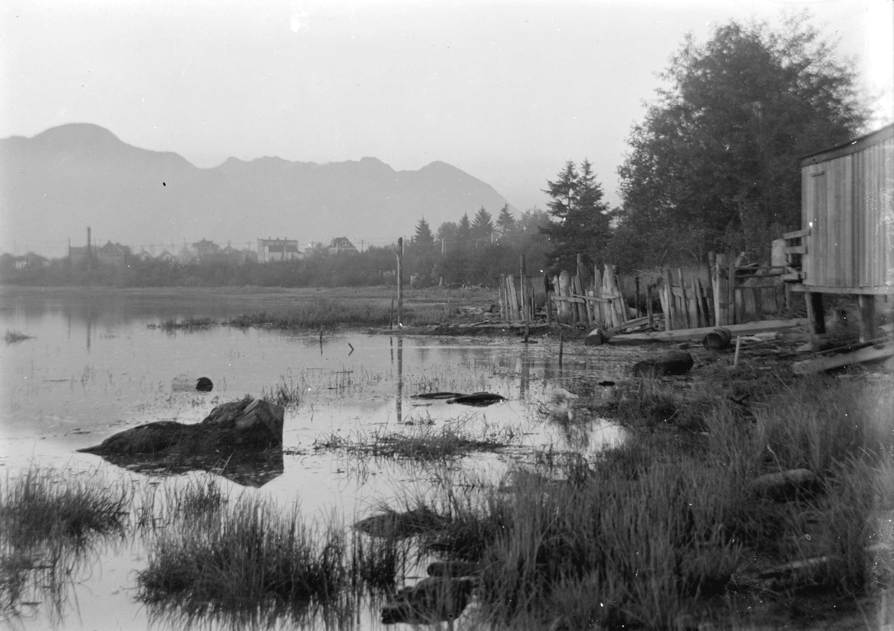
Shoreline area of False Creek Flats, Vancouver Archives, circa 1904
The False Creek floodplain between present-day Main Street and Clark Drive were once shallow tidal mud flats supporting a rich and diverse ecosystem.
When flooded at high tide, mudflats attract numerous species including juvenile salmon, seals, herons and ducks. These foraging shorebirds, fish and mammals feed on the thin nutritious “biofilm” layer that the mudflats provide.

Forage fish such as Pacific herring continue to play a key role in the ecology of False Creek. These small fish are preyed upon by larger fish, seabirds, and marine mammals, and their role is critical in the food web that sustains life on the Pacific Coast. Cormorants are seabirds that nest and feed in the False Creek area, diving underwater for small fish. Their presence in False Creek indicates there are forage fish in these waters.
By 1918, these tidal flats were paved over and the railway terminal was built here. The False Creek shoreline was increasingly paved as development in the area grew. In 1968 the industrial designation of False Creek was removed.
This project presents an opportunity to support the long-term work of enhancing the ecological health of this area.

-
Sea level rise
Share Sea level rise on Facebook Share Sea level rise on Twitter Share Sea level rise on Linkedin Email Sea level rise linkEast Park includes a portion of the False Creek shoreline and is entirely within the False Creek floodplain. As such, it is important to plan for sea level rise. Land in the East Park area is low and flat, and is therefore at greater risk of flooding relative to higher elevations in the city. Current projections estimate that one metre of sea level rise will be experienced in 2100 and an additional two metres of sea level rise by 2200 [source: False Creek Coastal Adaptation Plan]. The planning process for East Park will build on the City’s current initiatives related to sea level rise adaptation, including the False Creek Coastal Adaptation Plan (see ‘Documents’ in the side panel).

Documents

Videos
-
 Project introduction for East Park
-
 A new park is coming. East Park will be guided by the Belonging Statement, written by Rena Soutar, Manager of Decolonization, Arts and Culture at the Vancouver Board of Parks and Recreation.
-
 East Park includes a portion of the False Creek shoreline, and as such, it is important to plan for sea level rise. Land in the East Park area is low and flat, and is therefore at greater risk of flooding relative to higher elevations in the city.
Current projections estimate that over the next 30 years, Vancouver will experience about half a metre of sea level rise: one metre by 2100; and two metres by 2200 [source: False Creek Coastal Adaptation Plan]. The planning process for East Park will build on the City’s current initiatives related to sea level rise adaptation, including the False Creek Coastal Adaptation Plan.
East Park includes a portion of the False Creek shoreline, and as such, it is important to plan for sea level rise. Land in the East Park area is low and flat, and is therefore at greater risk of flooding relative to higher elevations in the city.
Current projections estimate that over the next 30 years, Vancouver will experience about half a metre of sea level rise: one metre by 2100; and two metres by 2200 [source: False Creek Coastal Adaptation Plan]. The planning process for East Park will build on the City’s current initiatives related to sea level rise adaptation, including the False Creek Coastal Adaptation Plan.
-
 Since 2020, we've been trialing urban meadows across the city to increase biodiversity, create new habitat for plants and pollinators and support climate resilience. In 2022, we will be extending the pilot to roadside boulevards and medians. Learn more at https://vancouver.ca/parks-recreation-culture/pollinator-meadows
Images

Contact us
-
Email east-park@vancouver.ca